Xplorer Maps Announces the Release of “San Francisco Bay”
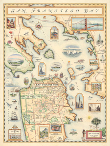
Xplorer Maps proudly announces the release of their hand-drawn, old-world style San Francisco Bay Area Map. A percentage of sales will benefit the San Francisco Museum and Historical Society.

Missoula, MT, February 12, 2013 --(PR.com)-- Xplorer Maps, founded in Missoula, MT in 2010, has released their most recent hand-drawn illustrated map; “San Francisco Bay”.
Xplorer Maps is dedicated to connecting, art, community and conservation and in keeping with their mission has partnered with the San Francisco Museum and Historical Society on this exciting new project. The original artwork has been donated for the SFMHS auction in April and a portion of sales from the prints will be donated to this organization in perpetuity.
With intricate detail, exquisite artistry and accurate historical reflection, Xplorer Maps is most notably known for their beautiful map illustrations of our nation’s most famous National Parks. With their signature antique, old-world style feel and uncompromising attention to detail, they are excited to include the San Francisco Bay Map to their ever-growing collection of hand-drawn maps.
The San Francisco Bay Map takes you on a journey through time with illustrative excerpts of the iconic architecture, renowned culture, historic neighborhoods and unique marine life of the region. “San Francisco Bay” will officially be released at the San Francisco International Gift Fair Feb. 16-19 but is available online now at www.xplorermaps.com.
Xplorer Maps is a registered Made in Montana business that uses exclusively 100% post-consumer content paper produced with 100% green energy and chlorine-free soy-based inks. Learn more at www.xplorermaps.com.
Contact
Xplorer Maps
Greg Robitaille
406-546-2659
www.xplorermaps.com
Greg Robitaille
406-546-2659
www.xplorermaps.com
Multimedia

San Francisco Bay Area Map
This San Francisco Bay Map explores it all with stunning, hand-illustrated graphics and rich historical excerpts. From The Bay Bridge to Treasure Island and from the giant pacific octopus to the leopard shark - if it's in, around or about The Bay, it's in there.
Categories
